Did that count? I don't think so. No-one had ever heard of the Picos de Europa.
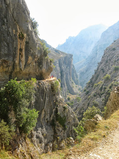
We only had 12 days for the hiking part of our holiday. That wouldn't get us far on the 800 km Camino, but we could readily hike 90-or-so km from village to village in the Picos. We were, after all, looking for a (mountain) peak experience: inspiring scenery, alpine flora and fauna, physical challenge and perhaps a few thrills as we traversed a narrow ridge or negotiated a precipitous descent. The Picos offers all these opportunities and also the pleasure of exploring the tiny villages in this unique region.
 |
| Scenery to soothe |
 |
| and inspire. |
When hiking in Europe we are usually completely independent; we make our own arrangements, cook our own food, and plan our own itinerary. This time, however, we decided to contract out some of our chores to one of several companies who organize outdoor adventures in the Picos. They would book our hotels (and meals), make sure our bags arrived on time, and provide an itinerary for 10 days of trekking that would take us from one central location (Arenas de Cabrales) to three other mountain villages and then back to Arenas.
 |
| On the trail above Arenas |
We wondered if, in our dotage, we were selling out by having S-cape do the heavy lifting for us. But we soon discovered we were not their only customers. All the younger hikers who were walking this circular route had also organized their holiday through this is or a similar company. It was the only sensible option, and it guaranteed a good meal, a decent bed, and no huge packs to carry.
Most importantly, our thick package of S-cape materials included detailed maps and directions for all the self-guided adventures we might want to experience-- treks that would allow us to explore a new destination for a day or two, and treks that would get us to our next village following a combination of farm tracks, back roads, marked hiking trails and ancient stone footpaths. The lengthy notes with directives such as "Walk through archway with old mining wagon on top. At fork go right (stony pathway, up hill toward hut) for 50 metres" would ensure that we always knew where we were. That was the theory. It worked most of the time.
 |
| Is that the Bay of Biscay in the distance? One rock looks like another, and we have made a wrong turn... |
 |
| Ian consults our maps. |
Youth and GPS? Life is so unfair.
No comments:
Post a Comment